Carta Indigena
The only known indigenous Filipino map—an 18th-century Iranūn-Ugi portulan documenting the complete South China Sea with red-marked sovereignty claims predating all modern assertions.
AMN-58-16: The Map That Changes Everything
Housed in the Archivo del Museo Naval (Madrid), this portulan represents the indigenous perspective of maritime Southeast Asia—unfiltered by colonial cartography.
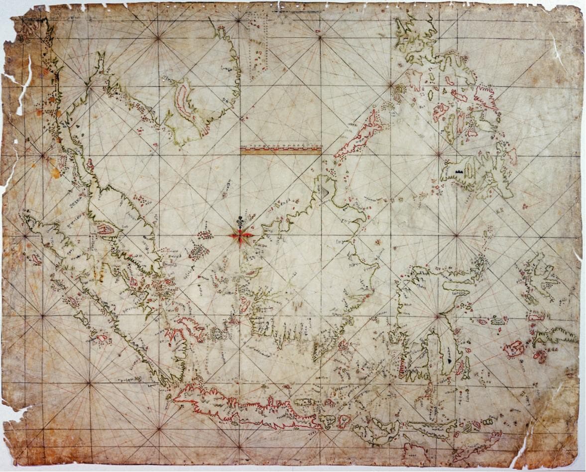
Archive Reference: AMN-58-16
Archivo del Museo Naval, Madrid • 18th Century
What is a Portulan Map?
Portulan charts were navigation maps used by seafarers, emphasizing coastlines, harbors, and sailing routes. Unlike land-based territorial maps, portulans documented maritime dominion—precisely what the Iranūn exercised.
"This map is the smoking gun. It predates European colonial claims and demonstrates that the Iranūn didn't just visit these islands—they controlled them."
— Dr. Rene Escalante, National Historical Commission of the Philippines
The Red-Marked Sovereignty
The Carta Indigena uses red ink to mark specific locations—a cartographic convention indicating active occupancy or territorial claims.
These are not trade ports or waypoints. They are bailiwicks—forward operating bases where the Iranūn maintained permanent or semi-permanent presence.
Palawan (Têbouk)
The map shows multiple red-marked settlements along Palawan's coast, indicating extensive Iranūn colonization. These were not temporary camps but multigenerational communities.
Sulawan (Spratly Islands)
Red markings on multiple atolls prove the Iranūn didn't just pass through—they established infrastructure for monsoon layovers and fleet repairs.
Panakot (Scarborough Shoal)
Marked with indigenous nomenclature ('panakot sa déwata'), demonstrating both physical presence and cultural/religious significance.
Pulo Condor (Côn Sơn)
Red-marked trading posts connecting to Champa and Đại Việt markets, showing controlled commercial networks.
What Foreign Maps Omit
Chinese Maps (Ming-Qing Dynasties)
Chinese imperial maps focus on coastal provinces and tribute states. The South China Sea is largely depicted as empty space beyond their administrative reach. The modern "Nine-Dashed Line" has no historical cartographic precedent.
The Qing court never claimed Sulawan or Panakot. Their tributary system didn't extend to mid-ocean islands.
Why This Map Holds Legal Weight
Under international law, historical title to territory requires proof of:
1. Effective Occupation
The red-marked bases demonstrate physical presence and infrastructure development.
2. Continuous Use
Documented maritime routes prove sustained economic and strategic use over centuries.
3. Sovereign Acts
Naming rights ('Panakot', 'Sulawan') indicate assertion of territorial authority.
4. External Recognition
European maps (like Murillo Velarde) acknowledged Iranūn nomenclature and presence.
The Carta Indigena satisfies all four criteria—making it arguably the most legally robust territorial claim in the South China Sea dispute.